
Introduction
The timely and exact delivery of combat force to the desired area of interest depends on the strong infrastructure with the nation. The ability of the infrastructure to support the operations will be just as important in the 21st century as the combat prowess of the armies in the tactical battle area. Therefore, having a powerful, modernised force supported by a sufficient infrastructure is a necessity for winning wars. Since the last 20 years, China has strategically focused on its western border, resulting in methodical infrastructure development in the Tibet Autonomous Region and Xinjiang. India on the contrary has developed infrastructure at a very slow, thus impinging the build up and logistic sustenance of own military operations. “India and China share a 3488 km long disputed border, 1597 km in Eastern Ladakh, 545 km in Central Sector of Himachal Pradesh and Uttarakhand, 220 km in Sikkim and 1126 km in Arunachal Pradesh. Over 110,000 sq km of India’s territory is claimed by China as well”[1]
India’s Strategy of Denial
After 1962 war with China, India developed a strategy to avoid substantial territorial loss in the mountains by denial of access to the axis for developing operations by the opponent. Hence, “the ‘strategy of denial’ was adopted where infrastructure development was deferred in the border areas along the Line of Actual Control (LAC). While India had stalled its development, China invested heavily in developing dual use infrastructure in terms of communication, billeting facilities and logistics to ensure seamless support for sustaining the war efforts.
“In 2007, Mr AK Antony, the then Raksha Mantri, was surprised by what he experienced at border post at Nathu La in East Sikkim and he referred it as ‘an eye-opener’. He saw that the Chinese had developed black top roads right up to their forward border posts. Indian soldiers on the other hand, had to walk for miles to reach their posts along the LAC, which would be a logistical nightmare during a conflict”[2].Until a decade ago, infrastructure was not regarded as a component of a comprehensive national capability and never took military operations into account. Infrastructure development was left to the discretion of political and government leadership / officials, while the Defence Forces concentrated only on force expansion and purchasing weapons / equipment. It is pertinent to mention that even if India has military parity to maintain the status quo along its northern borders, the lack of infrastructure will denude the deployment of combat power up to its full potential.
Comparative Analysis of Infrastructure Between India and China
Since the 1950s, China has maintained control over Tibet, which it views as its own vital part. When the People’s Liberation Army invaded the region in 1951, connect between Tibet and mainland China was quiet irregular. Today, a sophisticated network of highways, railroads and air routes connects it to the rest of the world. In addition to recent PLA reforms, this dual-use infrastructure developed by China facilitates it to manage the threats posed by its unresolved border with India. Infrastructure growth assists China in keeping the unrest in the restive Tibetan region under control.
There is a significant gap in the development of infrastructure between India and China, with the latter having a lead. India is hampered by a lack of financial resources, difficulties in land acquisition and uncommon goals between military civil requirements of developing infrastructure. Construction of communication, logistics buildup, secure storage facilities, underground missile / ammunition silos, long-range vector location, optic fibre communication, befitting capability to accommodate fighting formations including their maintenance, shelter for acclimatising troops for rapid deployment and construction of permanent defence works are some of the many infrastructure gaps. “Unlike the Tibet Plateau, which has a flatter landscape, the southern Himalayas have mountains and are drained by rivers. Only four to five months a year, excluding the monsoon and winter, are suitable for infrastructure development, so the weather has a significant impact. India’s existing communication infrastructure runs almost parallel to perennial rivers and through valleys which is a serious problem. Highways are hence susceptible to landslides and flooding.”[2]. Before sending troops and equipment to the border regions to develop them, one of the most crucial tasks after the winter and monsoon is to re-establish contact. As a result, the Border Roads Organisation (BRO) and other organisations have narrow window of time to finish new projects, which results in very slow pace of infrastructure development. Geologists claim that the continent continues to move along river courses (where glaciers are melting on higher levels) as a result of water seeping beneath it. Highways that cross valleys are frequently interrupted before, during and after both wet and dry seasons. No one wants to be the first to recommend that the roads be reconstructed and built along the upper reaches or over mountain ranges because so much money has already been spent on these failed arteries. An old Chinese saying that states “to get rich, one must build roads” is accurate in stating that the building of road infrastructure is necessary for year-round military activity support.
China’s Infrastructure Development
Despite the CCP’s dominance over Tibet dating back to the early 1950s, it wasn’t until China’s launch of the ‘Go West Campaign’ in 1999 as part of its ‘West Development Strategy’ that the scale of regional development intensified. Due to large part to well-coordinated civil-military fusion, the construction of dual-use civilian infrastructure and recent military upgrades, China has gained an operational edge along its border with India. In addition to communication channels, China’s three main arteries, oil pipelines, internet and power connectivity as well as more recent ‘well-off communities in border areas’ have all aided in development and protection its border areas. “The total road network in Tibet in 1959 was only 7,300 km which amplified to 1,20,000 km by early 2022 expanding at approximately 5 km per day since 1959”[i]. “Under its 10th and 11th Five Year Plans, China invested $ 4.2 billion and $ 21 billion to undertake 117 and 188 key infrastructure and development projects in Tibet”[3]. “During the Work Symposium in year 2020, Xi Jinping mentioned the need for construction of numerous major infrastructure and public service facilities around Sichuan-Tibet railway also to build more unity lines and happiness roads. He further emphasized it as one of the five developments to improve people’s livelihood and unite people’s hearts”[4]. “Under the current 14th Five Year Plan, China has planned expenditure of approximately $ 30 billion on infrastructure projects in Tibet in the period 2021 to 2025”[6]. By 2025, Tibet will exceed 1300 km of expressways and total to over 1,20,000 km of highways. “Tibet related projects in the 14th Five Year Plan include the Ya’an to Nyingchi phase of the Sichuan Tibet Railway line, preliminary work on the Hotan-Shigatse and Gyirong-Shigatse railway lines and the Chengdu-Wuhan-Shanghai high speed railway network. The plan includes upgrading the national highways G – 219 and G – 318 both of which run parallel to the India – China border near Ladakh and Arunachal Pradesh”[7].
- Roads and Railroads. China’s road and railroad projects in Tibet are enumerated in the table below which include national highways and railroads connecting mainland China to Tibet, Tibet to Xinjiang and the intra-province network :-
| Project Description | Project Details |
| “Roadways | |
| National Highway G 6 / G 109 | G 109 connects Beijing to Lhasa. The G 6 is the portion that connects Lhasa to Xining in Qinghai. The construction for the 1,897 km Xining – Lhasa stretch commenced in February 2018. |
| National Highway G 219 / G 564 | G 219 connects Xinjiang to Tibet. It originates from Yecheng in Xinjiang and terminates at Lhatse in Tibet. It runs along entire western and southern border of China. The road was constructed in 1957, however, under 13th Five Year Plan, China started upgrading it. G 564 will emerge from G 219 and will reach Purang near the China-India-Nepal tri-junction. It will pass between Mansarovar and Rakshas lake. |
| National Highway G 318 | It is the longest China NH (5,476 km). The 14th Five Year Plan plans extension of G 318 which connects Shanghai to Tibet through Chengdu in Sichuan. It then enters Nepal near Zhangmu near the China-Tibet border. The road passes through Nyingchi close to the China – India border near Arunachal Pradesh and a feeder road originating from G 318 also reaches opposite Tawang. |
| National Highway G 317 | G 317 originates in Chengdu, Sichuan and runs parallel to G 318 through Chamdo and Nagqu before meeting G 109 which meets G 318 at Lhasa. |
| National Highway G 580 | G 580 connects Aksu in Xinjiang to Kangxiwar through Hindutash through a tunnel and Hotan. |
| Other Important Highways | G 315 (East-west highway connecting Qinghai and Xinjiang), G 314 (connecting Urumqi and Khunjerab Pass), G 216 (linking northern Xinjiang to Kyirong County in Tibet by meeting G 218 near Hejing county in Xinjiang). |
| Railroads | |
| Sichuan – Tibet Line | Divided into three sections : Chengdu to Ya’an Section (140 km) which opened in December 2018, Lhasa to Nyingchi Section (435 km) which opened in June 2021 and Ya’an to Nyingchi Section (1, 011 km) which is likely to be completed by 2030. |
| Qinghai – Tibet line | The construction began in 2001 and was completed by 2006. This line was further extended up to Shigatse in 2014. The only railway that connects China mainland to Tibet. The length is 1,956 km. |
| Shigatse-Yadong Extension | The Lhasa – Shigatse line will be further extended from Shigatse to Yadong County. Yadong County is the last county on the China – India border near Sikkim and adjacent to India’s Nathu la pass. |
Shigatse-Gyirong-Kathmandu (China – Nepal Rail) | Was to be completed by 2022 but project stuck up due to various issues. |
| South Xinjiang-Tibet Loop | Hotan – Shigatse line (825 km – under construction) largely follows G 219 route – unknown if it would enter Aksai Chin region like the highway, Hotan – Ruoqiang line (Xinjiang – under construction), Ruoqiang – Korla section of the Golmund – Korla line (in operation since 2014) and Gomund – Lhasa Section of the Qinghai -Tibet line (in operation since 2006).Together, these lines form the Tibet – South Xinjiang loop connecting most major cities in the region. |
| Other Important lines | Yunnan-Tibet line (still planned); 617 km Dunhuang – Golmud Railway (opened in 2019).”[8] |
- Airfields. 14th Five Year Plan plans for China to develop the Chengdu – Chongqing world-class airport cluster and expand Chongqing Jiangbei International Airport. In addition, China will develop 30 more civilian transport airports. “The construction of these 30 airports will be in addition to the 12 existing operational / under construction airports in Tibet and the South Xinjiang region along the borders with India”[9]. Since year 2012, China has launched 130 new air routes with 61 cities connected by plane. In addition, it has constructed numerous hardened storage facility for its military planes and equipment.
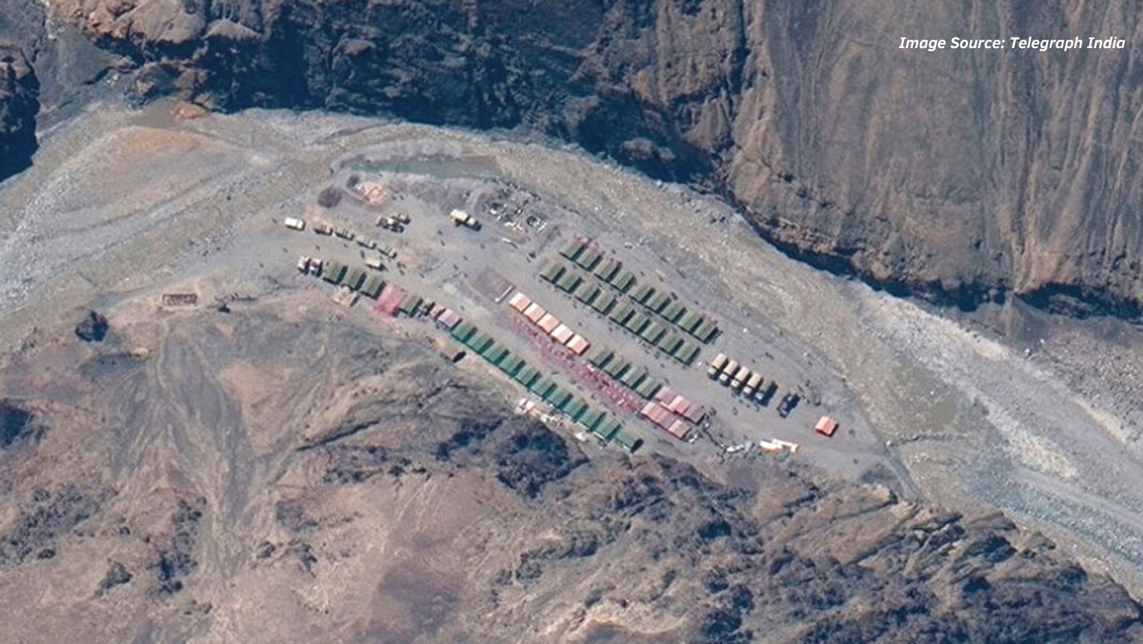
- Border Villages. The CCP apparatus in Tibet established the “Xiaokang villages initiative which called for the development of 628 villages (427 first line and 201 second line villages) along the Indian border in Tibet, spanning from Ngari Prefecture, which borders Uttarakhand and Himachal Pradesh, to Nyingchi, which borders Arunachal Pradesh”[10]. 354 villages out of the 427 front line villages are being constructed along the borders with Bhutan, Nepal and Arunachal Pradesh. “They are being constructed throughout 21 Himalayan border counties with 62,160 households and are expected to accommodate 62,000 persons. These villages which are inhabited by primarily CCP supporters, are presumably meant to act as a buffer between China and India, enhancing Beijing’s authority over these remote territories. According to Chinese officials, these border communities are being built to ensure ‘border cohesion and border security”[11]. China’s strategy has always exploited the civilian resources such as herders, farmers and fishing vessels to achieve military objectives on land or at sea. PLA has from time immemorial employed these nomadic tribes / herders for access to grazing pastures to advance territorial claims.
- Hydro Electric Projects. China has at a rapid pace developed and is further in the process of constructing a number of “hydro electric projects on river Yarlung Tsangpo(Brahmaputra). Four such dams opposite Arunachal Pradesh are expected to generate 2000MW of energy which will act as feeder for electricity to the entire national grid”[12]. The project on the Yang Tse river is expected to dwarf the record breaking ‘Three Gorges Dam’ and is expected to produce 300 billion kilowatt of electricity each year. The construction of these dams will impinge on the availability of water towards India and its related implications on various facets including security.
- Telecommunication. China has commenced exploiting the 5G network facilities in border villages with high speed data connectivity in each smart home in the remotest border areas. Apart from providing state of art facilities to the residents it would also boost the surveillance capability of the villages for military benefits.
- Faster mobilization & provision of flexibility for timely application of force.
- Achieving superiority at point of decision with timely application of
- Provision of diverse options for deployment / sustaining military capability.
- Dominating the battle space and denying opportunity to the adversary.
China’s Operational Edge. The border of India with China is always vulnerable considering China’s aggressive policy and large scale border transgression attempts along the LAC. Due to the advantage of terrain, China has eight months window to build and launch operations across the Himalayas, whereas India has approximately four to five months only. Thus, own operational preparedness is hampered in the absence of all weather road connectivity and continuous operational logistics sustenance.
Chinese military doctrines adopts an approach of securing its territory through “border area counter attack campaign”[13]. These campaigns are conducted in two phases. The first phase begins with defensive operations to create a favorable condition for the counter attack after the adversary’s initial strike coupled with the non kinetic options. The second phase includes counter attacking post arrival of the main kinetic force in the theatre of operation. As per the latest doctrinal modification, China would employ its Rocket Force (kinetic option) coupled with non kinetic options to address the adversary’s hinterland and immobilize the forces prior to their induction in order to isolate the tactical battle zone in the initial phases itself. Hence, it is pertinent for India to develop additional infrastructure in the tactical battle area to fight an effective battle and ensure sustenance of the forces deployed in forward areas.
The upgraded infrastructure of China facilitates its military with quicker mobilization to be employed against India. Chengdu and Lhasa are connected by the 1838 km Sichuan-Tibet Railway. The normal travel time via existing roads and rail between Chengdu and Lhasa in the event of a confrontation with India is nearly 40 hours. Once completed, the Sichuan-Tibet railway will cut this time to half enabling much faster mobilisation. China is building many road and rail networks to connect Tibet to the rest of China and Xinjiang. On completion of these projects in next 10 to 12 years, the PLA, the People’s Armed Police (PAP) and the border defense forces will mobilise much faster as also sidestep its forces faster to maintain unpredictability and flexibility in application of forces. In addition, it has also developed state of art defenses and hardened shelters for equipment and logistics, thus enhancing sustenance capability in forward areas, thereby boosting its operational preparedness manifolds.
China’s Logistic Edge During Protracted Conflict. Both India and China have increased their forward force deployment along the LAC in response to recent standoffs. National and provincial highways have been built by China and feeder roads have been connected to them from significant Tibetan border towns. These feeder roads, despite difficult terrain and adverse weather enable the advance deployment of troops and ensure prompt resupply of logistics and other necessities. Additionally, they have created state of art facilities for accommodating troops and storing logistics such as hardened / underground silos for ammunition / equipment in the tactical battle areas. Improved infrastructure also facilitates China to integrate the restive Tibetan region which definitely has an impact on its internal stability and border security. On the contrary, India is still trying to strike a balance between national security and environmental concerns – having an impact on its combat capability and preparedness.
Options for India
India after arduous standoffs including Doklam and Galwan realized, though quite late as a nation, that its primary adversary was not on the West, but along the Northern borders. India in fact had already developed its ‘Look East Policy’ in 1991 which was crawling to develop the North East. It was further rechristened as ‘Act East Policy’ in 2014 to steer it with a rejuvenated impetus. Effort is required by the present political dispensation at all levels to be pushed as a ‘whole of nations approach’ with infrastructure needed for development of holistic civil – military capabilities. It would enhance the operational efficacy, flexibility and multiple options to fight both conventional and sub-conventional conflicts. The government needs to lay down diligent roadmap, strict timelines with accountability so that the stakeholders meet the operational parameters. Focused and stern decisions are a necessity in consonance with the operational requirements rather than contractual obligations.
- Developments Undertaken. The completion of 255 kilometer all weather strategic Darbuk – Shyok – Daulat Beg Oldie (DSDBO) road in Ladakh was a matter of apprehension for China. In addition, operationalization of nine kilometers Atal Tunnel in October 2020 which provides an alternative / shorter induction route to Ladakh has been another cause of China’s frown. Few other infrastructure developments undertaken in the recent past / planned for near future by India are enumerated as under :-
- Development of 20 bridges across Arunachal Pradesh.
- Tunnels at Nechiphu and Sela pass in Arunachal Pradesh.
- Development of OKSRT as alternate route from Guwahati to Tenga.
- Roads along Tenga to Itanagar and Western Axis Shergaon to Tawang as also roads along the valleys / inter valley in Rest of Arunachal Pradesh (RALP).
- 12 projects covering approximately 900 km under Special Accelerated Road Development Program.
- Focused approach of North Eastern Council on building approximately 10,500 km roads including inter state roads.
- “Tunnel underneath Brahmaputra being surveyed and planned as a major project”[14].
- Rail projects to include Jiribam – Imphal (110 km), Bhairabi – Sairang (50 km), Dimapur – Kohima (85 km), Teteliya – Byrnihat (25 km) and Agartala – Akhaura (15 km).
- 4,000 km of roads, 20 railway projects for 2,011 km and 15 air connectivity projects are being developed in the North East.
- “Construction of Bogibeel bridge over Brahmaputra river, 20 major railway projects encompassing 13 new lines, two gauge conversion and five doublings with a length of nearly 2,624 km for North East states. Construction of bridge on Shyok river, Shinkun La tunnel and Saser La in Ladakh as also numerous roads to enhance inter area / valley connectivity.
- National Waterways NW-1 on the Ganga, NW-2 on Brahmaputra and NW-16 on Barak are under development to provide better inland water connectivity.
- Eastern Waterways Connectivity Transport Grid which will connect the northeast with the rest of India by providing 5,000 km of navigable waterways”[15].
- Government is also emphasizing on projects related to power transmission / distribution, 4G network and broadband connectivity to border areas.
- Indian government has recently approved construction of largest hydropower project at Dibang (Arunachal Pradesh).
- “Prime Minister’s Development Initiative for border areas funding infrastructure from PM Gati Shakti (construction of multi-use infrastructure) and social development projects based on felt needs”[16].
- Development of air connectivity through UDAN scheme. Construction of airports at Pakyong (Sikkim), Tezu (RALP), Thoise (Ladakh) and extension / improvement to existing airport
- Plan for infrastructure for tourists to enhance tourism in far flung areas.
Way Ahead. India has already realized the primacy of the adversary along Northern borders. Due impetus by the government to develop the border areas along with areas leading to it needs to be executed on war footing. A ‘whole of nations approach’ with additional central and state budgets being utilized for the purpose are required to be undertaken. The various ministries of the Central and State government need to cohesively resolve minor issues and ensure concerted effort for the cause. A way forward to ensure concerted effort for infrastructure development along northern borders are enumerated as under :-
- An integrated apex level committee to monitor the development along the Northern borders as also a better civil – military fusion during planning and execution stage.
- Construction of roads and railway along with tunnels in vulnerable areas to enhance round the year connectivity to last post along the borders. Multiple laterals / axials to be developed to ensure flexibility in options for application of forces.
- Construction of model villages and rehabilitation of villages along the LAC for better dominance of border areas.
- Construction of military and civil airfields along with helipads in forward areas. Development of additional civil airports under UDAN scheme.
- Establishment of better civil – military fusion mechanism to ensure faster and cohesive planning / execution of projects.
- Establishment of better tele-communication (both mobile and fibre optics) infrastructure to ensure better communication facilities to military and civil populace in border areas.
- Construction of additional tunnels to enhance cross valley connectivity, underground storage for logistics / ammunition & long range vectors and accommodation for troops / equipment.
- Establishment of accountability for delays and proper monitoring of projects by a standing committee at the Apex level.
- Enhancement of tourism in forward areas along with requisite infrastructure to support it.
Conclusion
India has in the recent past realized its infrastructure voids along the northern borders and concentrated its focus on the development in these areas. However, it is presently far from being anywhere near Chinese infrastructure development graph along the LAC. India needs to ensure fast pace development along the border areas opposite China to ensure operational parity. A concerted ‘whole of nations approach’ is required to be adopted to ensure a potent national security architecture is established against our primary adversary ie. the northern adversary.
DISCLAIMER
The paper is author’s individual scholastic articulation and does not necessarily reflect the views of CENJOWS. The author certifies that the article is original in content, unpublished and it has not been submitted for publication/ web upload elsewhere and that the facts and figures quoted are duly referenced, as needed and are believed to be correct.
BIBLIOGRAPHY
- “10th & 11th Five Year Plan of China – Bing Images.” Accessed February 18, 2023. https://www.bing.com/images/search=10th+11th+five+year+plan+of+china&qpvt=10TH+AND+11TH+FIVE+YEAR+PLAN+OF+CHINA&form=IGRE&first=1.
- “Brahmaputra Tunnel || Welcome to Border Roads Organisation.” Accessed February 19, 2023. https://marvels.bro.gov.in/BROMarvels/BrahmaputraTunnel.
- Burke, Edmund J., Kristen Gunness, Cortez A. III Cooper, and Mark Cozad. “People’s Liberation Army Operational Concepts.” People’s Liberation Army Operational Concepts, November 10, 2020. https://doi.org/10.7249/RRA394-1.
- “China’s New Dam on Brahmaputra.” Accessed February 18, 2023. https://www.drishtiias.com/daily-updates/daily-news-analysis/china-s-new-dam-on-brahmaputra.
- “China Building Multiple Villages along Borders with India, Satellite Images Reveal.” Accessed February 18, 2023. https://www.moneycontrol.com/news/india/china-building-multiple-villages-along-borders-with-india-satellite-images-reveal-7739431.html.
- “China Continues to Expand Infrastructure and Upgrades Air Bases in Tibet | The Financial Express.” Accessed February 18, 2023. https://www.financialexpress.com/defence/china-continues-to-expand-infrastructure-and-upgrades-air-bases-in-tibet/2627807/.
- “China to Invest $30 Billion for Infra Development in Tibet over next 5 Years – BusinessToday.” Accessed February 18, 2023. https://www.businesstoday.in/latest/world/story/china-to-invest-30-billion-for-infra-development-in-tibet-over-next-5-years-290330-2021-03-09.
- “Chinese Road Construction in Tibet Exceeded 1.20 Lakh Kms in 2021: Report – India Today.” Accessed February 18, 2023. https://www.indiatoday.in/world/story/china-
- tibet-lhasa-road-construction-1926653-2022-03-17.
- Costa, Rui Miguel. “Denial (Defense Mechanism).” Encyclopedia of Personality and Individual Differences, 2017, 1–3. https://doi.org/10.1007/978-3-319-28099-8_1373-1.
- Gen, Lt, and Vinod Bhatia. “CHINA’s INFRASTRUCTURE IN TIBET AND POK-IMPLICATIONS AND OPTIONS FOR INDIA Centre for Joint Warfare Studies (CENJOWS) New Delhi,” 2016. www.xtremeonline.in.
- “India Prepares for Threat at LAC as China Constructs ‘dual-Use’ Border Villages.” Accessed March 29, 2022. https://www.msn.com/en-in/video/news/india-prepares-for-threat-at-lac-as-china-constructs-dual-use-border-villages/vi-AAPK29v.
- “Infrastructure Development in North East India.” Accessed February 19, 2023. https://www.drishtiias.com/daily-updates/daily-news-analysis/infrastructure-development-in-north-east-india.
- “Infrastructure Development in Tibet and Its Implications for India – Jamestown.” Accessed February 18, 2023. https://jamestown.org/program/infrastructure-development-in-tibet-and-its-implications-for-india/.
- “Issue Brief – China’s 14th Five-Year Plan | United Nations Development Programme.” Accessed February 18, 2023. https://www.undp.org/china/publications/issue-brief-chinas-14th-five-year-plan.
- “Jamestown Issue Brief – Infrastructure Development in Tibet and Its Implications for India – The Takshashila Institution.” Accessed March 29, 2022. https://takshashila.org.in/infrastructure-development-in-tibet-and-its-implications-for-india/.
- Lai, Hongyi Harry. “China’s Western Development Program: Its Rationale, Implementation, and Prospects.” Modern China 28, no. 2 (2002): 436. https://doi.org/10.1177/009770040202800402.
- “Line of Actual Control (LAC): Where It Is Located, and Where India and China Differ
- Explained News,The Indian Express.” Accessed February 18, 2023. https://indianexpress.com/article/explained/line-of-actual-control-where-it-is-located-and-where-india-and-china-differ-6436436/.
- “Major Infrastructure Development In North-Eastern States: Road, Rail, Air Connectivity.” Accessed February 19, 2023. https://www.proptiger.com/guide/post/a-look-at-infrastructural-developments-in-north-eastern-states-of-india.
- “Neglect of India’s Frontier Areas – Indian Defence Review.” Accessed March 29, 2022. http://www.indiandefencereview.com/news/neglect-of-indias-frontier-areas/.
- “People’s Liberation Army Operational Concepts | RAND.” Accessed February 19, 2023. https://www.rand.org/pubs/research_reports/RRA394-1.html.
- “PM Gati Shakti – National Master Plan for Multi-Modal Connectivity| National Portal of India.” Accessed February 19, 2023. https://www.india.gov.in/spotlight/pm-gati-shakti-national-master-plan-multi-modal-connectivity.
- “Xi Jinping: Speech at the Symposium of Scientists – Center for Security and Emerging Technology.” Accessed February 18, 2023. https://cset.georgetown.edu/publication/xi-jinping-speech-at-the-symposium-of-scientists/.
Endnotes
- “Neglect of India’s Frontier Areas – Indian Defence Review,” accessed March 29, 2022, http://www.indiandefencereview.com/news/neglect-of-indias-frontier-areas/.
“Line of Actual Control (LAC): Where It Is Located, and Where India and China Differ | Explained News,The Indian Express,” accessed February 18, 2023, https://indianexpress.com/article/explained/line-of-actual-control-where-it-is-located-and-where-india-and-china-differ-6436436/.
“Chinese Road Construction in Tibet Exceeded 1.20 Lakh Kms in 2021: Report – India Today,” accessed February 18, 2023, https://www.indiatoday.in/world/story/china-tibet-lhasa-road-construction-1926653-2022-03-17.
“10th and 11th Five Year Plan of China – Bing Images,” accessed February 18, 2023, https://www.bing.com/images/search?q=10th+and+11th+five+year+plan+of+china&qpvt=10TH+AND+11TH+FIVE+YEAR+PLAN+OF+CHINA&form=IGRE&first=1.
“Xi Jinping: Speech at the Symposium of Scientists – Center for Security and Emerging Technology,” accessed February 18, 2023, https://cset.georgetown.edu/publication/xi-jinping-speech-at-the-symposium-of-scientists/.
“Issue Brief – China’s 14th Five-Year Plan | United Nations Development Programme,” accessed February 18, 2023, https://www.undp.org/china/publications/issue-brief-chinas-14th-five-year-plan.
“China to Invest $30 Billion for Infra Development in Tibet over next 5 Years – BusinessToday,” accessed February 18, 2023, https://www.businesstoday.in/latest/world/story/china-to-invest-30-billion-for-infra-development-in-tibet-over-next-5-years-290330-2021-03-09.
“Jamestown Issue Brief – Infrastructure Development in Tibet and Its Implications for India – The Takshashila Institution,” accessed March 29, 2022, https://takshashila.org.in/infrastructure-development-in-tibet-and-its-implications-for-india/.
“China Continues to Expand Infrastructure and Upgrades Air Bases in Tibet | The Financial Express,” accessed February 18, 2023, https://www.financialexpress.com/defence/china-continues-to-expand-infrastructure-and-upgrades-air-bases-in-tibet/2627807/.
“China Building Multiple Villages along Borders with India, Satellite Images Reveal,” accessed February 18, 2023, https://www.moneycontrol.com/news/india/china-building-multiple-villages-along-borders-with-india-satellite-images-reveal-7739431.html.
“Infrastructure Development in Tibet and Its Implications for India – Jamestown,” accessed February 18, 2023, https://jamestown.org/program/infrastructure-development-in-tibet-and-its-implications-for-india/.
“China’s New Dam on Brahmaputra,” accessed February 18, 2023, https://www.drishtiias.com/daily-updates/daily-news-analysis/china-s-new-dam-on-brahmaputra.
“People’s Liberation Army Operational Concepts | RAND,” accessed February 19, 2023, https://www.rand.org/pubs/research_reports/RRA394-1.html; Edmund J. Burke et al., “People’s Liberation Army Operational Concepts,” People’s Liberation Army Operational Concepts, November 10, 2020, https://doi.org/10.7249/RRA394-1.
“Brahmaputra Tunnel || Welcome to Border Roads Organisation,” accessed February 19, 2023, https://marvels.bro.gov.in/BROMarvels/BrahmaputraTunnel.
“Major Infrastructure Development In North-Eastern States: Road, Rail, Air Connectivity,” accessed February 19, 2023, https://www.proptiger.com/guide/post/a-look-at-infrastructural-developments-in-north-eastern-states-of-india; “Infrastructure Development in North East India,” accessed February 19, 2023, https://www.drishtiias.com/daily-updates/daily-news-analysis/infrastructure-development-in-north-east-india.
“PM Gati Shakti – National Master Plan for Multi-Modal Connectivity| National Portal of India,” accessed February 19, 2023, https://www.india.gov.in/spotlight/pm-gati-shakti-national-master-plan-multi-modal-connectivity.